Edito
What is the origin of volcanoes? How did mountain ranges form? Why do earthquakes occur and why are they so devastating? How and where one should look for the so precious groundwater? How did ore and mineral deposits, and oil and gas fields form? Why do glaciers melt and what will be the impact on global climate? This was because we were asking ourselves such questions that we decided to become geologists.
This scientific discipline is often unknown from the public, even depreciated, because the considered phenomena are usually very slow and seem non-existing at human time scale. Nevertheless, the Earth is a living and evolving planet, and the phenomena that occurred during its life are at the origin of water, so important for life, and of the resources of minerals and fossil fuels permanently consumed by industry. Thus, behind a large number of daily use objects, there was a geologist who discovered an iron or copper deposit, an oil or gas field, or exploitable groundwater.
During the journey of the Andean Geotrail, we invite you to follow us along the Andean Cordillera in order to discover our planet through the sights of geologists. We will visit exceptional geological localities illustrating their beauty, their economic implications and the natural hazards they represent. In addition, we will collect geological information that allows us to understand the phenomena at the origin of the fantastic Andean geology. We will also go towards the local populations, whose lives depend on those geological localities. We thus hope that the Andean Geotrail will allow you to look at our planet with another sight.
Itinerary
The route of the Andean Geotrail follows and crosses the Andean Cordillera from South to North. During the journey, we will cross five regions that are geographically, geologically, climatically and sociologically distinct.
With 10 000 kilometres of distance, passes higher than 4700 metres, the crossing of high plateaus, deserts and very wet areas, extreme temperatures from -25°C to 45°C, furious winds, the Andean Geotrail is a major physical challenge. In order to face such harsh conditions, we will undergo suitable training.
The various climates and seasons are major constraints on the organisation of the expedition. Departure is scheduled for November 2008 in order to benefit from the Patagonian spring. With a planned daily average distance of 40-50 kilometres and planning some resting and visiting periods, we anticipate our arrival in Lima 9 months later in August 2009.
- The Tierra del Fuego is the southernmost tip of the South America continent. It hosts Ushuaia, our departure point and the southernmost city in the world. Tierra del Fuego is an island separated from the main land by the Magellan’s Straight, which marks a major geologically active fault. We will face furious winds before crossing the straight by boat. Main cities: Ushuaia – Rio Grande – Porvenir (Magellan’s Straight).

- The Patagonia is mythic place in South America. Patagonia remains a wild land, sometimes void of human activitiy, and is characterized by a rough climate, ferocious winds, chaotic coasts, and a poorly developed road network. The various geological processes in Patagonia have resulted in diverse and truly spectacular region. In addition to its touristic attractiveness, Patagonia hosts large oil and gas reserves, gold, silver and copper. The selected geological sites are Torres del Paine (granitic intrusion), Glaciero Perito Moreno (Patagonian ice field), Villarica volcano, and the Neuquén Basin (petroleum province). Main cities: Punta Arenas – El Calafate – Tres Lagos – Coihaique – Tumeco – Chos Malal.
- The High Andes differ from the rest of the Andes by a lack of active volcanism. In contrast, deformation of the Earth crust has resulted in mountains that are the roof of the Americas: Cerro Aconcagua, 6959 metres high. This region holds rich ore deposits. In addition, the excellent combination of good climate and rich geological environment gave birth to the great Mendoza vineyard. Selected geological sites are Planchón-Peteroa volcano, Cerro Aconcagua, and the Mendoza region (Vineyard). Main cities: Chos Malal – Talca – Santiago – San Juan – La Rioja.
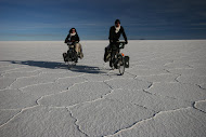
- The Altiplano-Puna consists of the central segment of the Andes and corresponds to a high plateau averaging 4000 metres. Their geological origin remains an enigma for geologists. This region gathers spectacular volcanic, desert and tropical landscapes. We will twice climb the flanks of the plateau, where we will have to adapt to the altitude. Both flanks of Altiplano are full of natural resources. We have selected the geological sites of Chuquicamata (biggest open mine in the world), Salar de Uyuni, Cerro Ríco de Potosí (silver mine). Main cities: La Rioja – San Pedro de Atacama – Potosí – Santa Cruz de la Sierra – La Paz.
- The Peruvian Andes hosted the Inca Empire and are famous for their gold. They notably host the sites of Machu Pichu and Cuzco. After La Paz, we will follow Titicaca Lake and will visit Ubinas active volcano. Then, we will reach the northern edge of the Altiplano where erosion formed deep canyons that we will have to cross. Finally, the descent to Lima will mark the end of the journey. Main cities: La Paz – Puno – Cuzco – Huancayo – Lima.